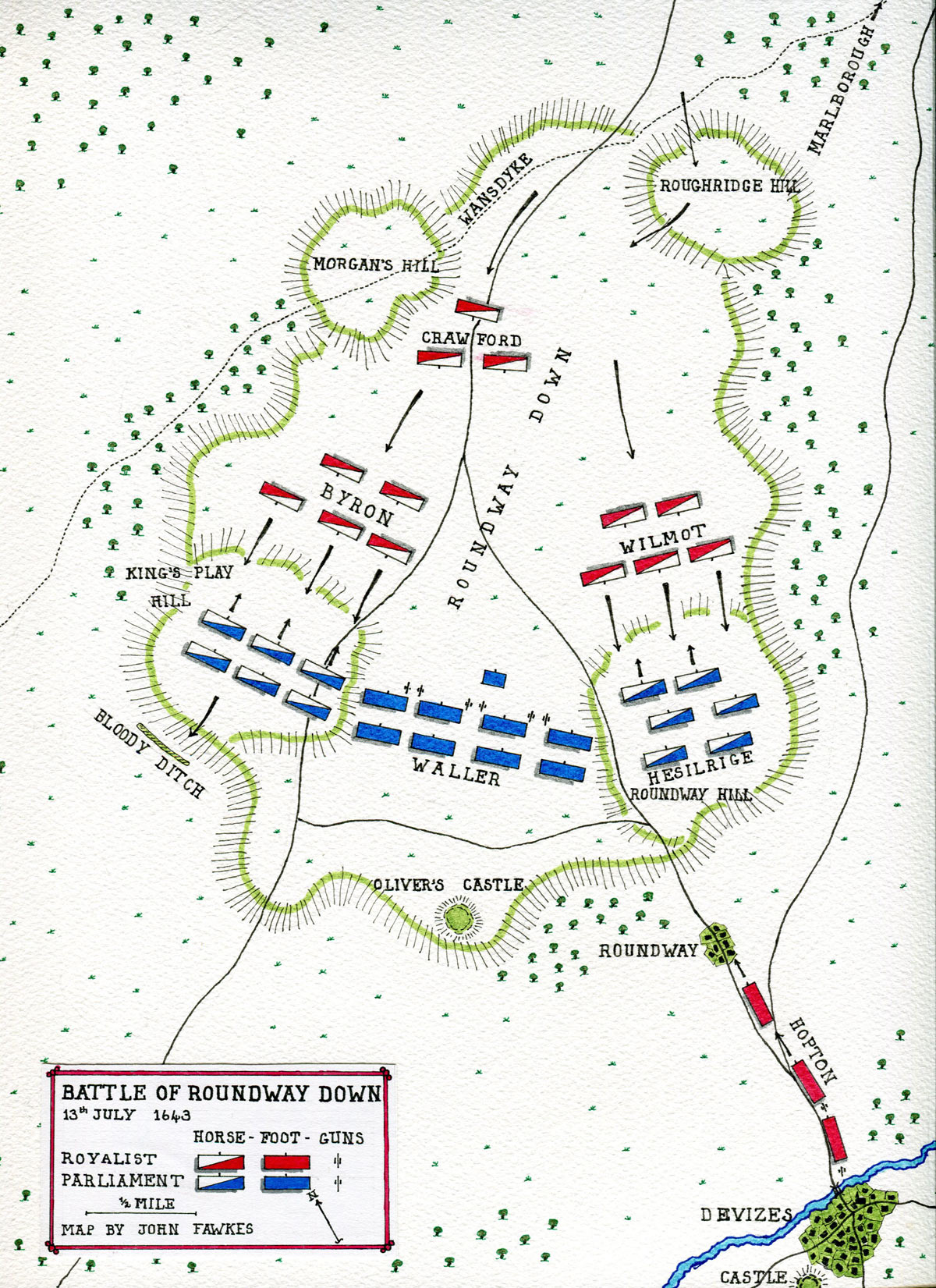
Spectacular day, but I was sorely lacking in battle orientation before I got to the site so I'm hoping the following will help any follow-on visitors.. as I said in the previous post, there really is very little battlefield layout information available on line
So I took as my source the first of the battlefield information boards - which is about as far from the front line action as it could possibly be (click on it to embiggen):
 |
| B1 on the map below |
Note that the Parliamentarian front line is deployed along the edge of the rise and roughly facing the Royalist horse on Morgan's Hill ... note also if you draw a straight line between Bloody Ditch and Bishops Cannings the Royalist deployment is just in front of it..
So on Google Maps I then pulled up Roundway Down and then turned on contours which gives me this..
So on Google Maps I then pulled up Roundway Down and then turned on contours which gives me this..
 |
| P = Parking |
Flipping between map view and satellite view then allows you to place the front line of the Waller's troops fairly concisely... caveat.. if the battlefield noticeboards are to be believed! 
First time I visited, I parked near the White Horse and in hindsight that is by far the better place to park for viewing where the fighting would have taken place.. this time I parked in the car park to the left but it's not a huge battlefield and everything is walk-able.. there is also an "official" car park over by Oliver's Castle (which isn't.... either "Oliver's" or "a Castle"..)

So on to the walk -
That's Morgan's Hill in the distance (following), taken from B1, it's handily marked by the two aerials and the copse of woods on top... the Royalist cavalry under Wilmot, Byron and Crawford attacked from there..

..and again.. the Parliamentarian front line was to the right of the picture

...and as if by magic.. note the copse of trees on the skyline left of centre - the Royalist troops would have been deployed just in front/left of them.. my initial research had lead me to believe (based on the web map I found) that the position was much further back than that (I thought about where the tractor is in the distance)

First though, having orientated myself, and because I was close - a view of Bloody Ditch
First time I visited, I parked near the White Horse and in hindsight that is by far the better place to park for viewing where the fighting would have taken place.. this time I parked in the car park to the left but it's not a huge battlefield and everything is walk-able.. there is also an "official" car park over by Oliver's Castle (which isn't.... either "Oliver's" or "a Castle"..
)
So on to the walk -
That's Morgan's Hill in the distance (following), taken from B1, it's handily marked by the two aerials and the copse of woods on top... the Royalist cavalry under Wilmot, Byron and Crawford attacked from there..

..and again.. the Parliamentarian front line was to the right of the picture

...and as if by magic.. note the copse of trees on the skyline left of centre - the Royalist troops would have been deployed just in front/left of them.. my initial research had lead me to believe (based on the web map I found) that the position was much further back than that (I thought about where the tractor is in the distance)

First though, having orientated myself, and because I was close - a view of Bloody Ditch
 |
| B2 on the map |
...which is bloody frightening - I was having trouble on foot and with a walking stick - 200m drop in the space of 50 yards?

Devizes..

Steep...


I then walked across the battlefield - basically from B1 back to the car park where I'd left the car taking the following view of the ridge where Waller deployed on the way..

...then walked up the hill - through the modern plantation (Leipzig), and you can walk down a farm track that takes you through his deployment - this is from just behind his deployment looking at Morgan's Hill...

...too your right is Bishops Canning's (following) where a number of the Parliamentary Infantry escaped too..

..I finished off by walking back to the car as I'd noticed that it was on the line of retreat taken by Hasalrig's Lobsters.. they would have been bundled down this hill which would have been much more open then..

Superb day out and rounded off by a trip to the Hop Back pub in Salisbury..!
Extra reading
- English Heritage Battlefields Register report for “Roundway Down”
- Battlefields Trust:
- Historic England: